

水是地球上重要的自然资源之一,其不仅是维持生命的基本要素,也是生态系统健康和社会经济发展的关键驱动力[1]。水体在生态系统中扮演着多种重要角色,包括调节气候、维持生物多样性、支持农业生产以及提供饮用水和工业用水等。水文循环受气候变化影响显著,随着全球气候变化加剧和人类活动的加剧,水资源的时空分布和质量正在发生变化[2]。在农业密集区如松嫩平原,水资源的动态监测对保障粮食安全、保护湿地生态系统以及维护区域生态环境的可持续性具有重要作用[3]。
1 材料与方法
1.1 研究区基本情况
1.2 数据来源与处理
2010年前后松嫩平原实施了多项生态补水和湿地恢复政策,如退耕还林还草,显著改善了生态环境,然而,对于补水效果和补水后的水文情势监测缺乏系统研究。因此,本文使用GEE平台2011—2020年松嫩平原西部所有云覆盖率低于10%的Landsat 5/7/8 TM/ETM+/OLI表面反射率(SR)图像。Landsat影像具有30 m的空间分辨率和16 d的时间分辨率。Landsat 7图像于2003年5月之后扫描线校正器(SLC)损坏,导致 ETM+图像中出现条带缺口[15]。利用GEE提供的Landsat 7 SLC-off Collection 1 Tier 1 SR影像集,是一种经过条带修复的数据集,使用了Gap-Fill算法,根据相邻的有效像元进行插值,填充无效像元。Landsat 5和7表面反射率数据集是由Landsat生态系统扰动自适应处理系统(LEDAPS) 算法生成的,Landsat 8表面反射率数据是根据Landsat表面反射率代码(LaSRC)算法生成的。所有数据均经过了大气校正和辐射校正,消除了大气散射、吸收以及传感器老化等因素的影响,同时进行了几何校正,确保影像的空间精度,便于多时相数据的叠加和对比。此外,GEE还使用了CFMask和FMask等云掩膜算法,自动识别并去除影像中的云层和阴影,从而提高数据的使用质量。不同分辨率的波段通过重采样技术统一,使各波段数据可以更精确的进行分析。
由于水体的物理属性,使其无法在陡峭的地面上孤立存在;同时斜坡相较于水平地面在遥感影像中因为其被卫星接收的反射强度低于一般水平地面从而被错分为水体。Landsat影像去除地形影响后,仍然需要将数字高程模型(Digital elevation model,DEM)作为影响因素用于评价是否存在水体。这些数据可以通过 GEE 平台公共数据目录进行访问。此外,SRTM数据用于获取松嫩平原西部的高程(Elevation)、坡度(Slope)和坡向(Aspect)。这3个参数用于评价水体覆盖情况。
根据GEE提供的Quickbird图像、辅助数据和现场采样,确定了研究区3种主要的水文情况:水体、植被和裸地(包含城市和未利用地)。针对每种水文情况选择感兴趣区(ROI),并提取它们的地表反射。为减少偏差,训练和测试样本随机分布在选定的ROI中。本文选取了9个植被指数、水体指数和地形指数用于区分水体、植被和裸地。在GEE中共选取了30 230个典型样本点,按7∶3比例划分,21 161个样本点作为训练样本对模型进行训练,9 069个样本点作为验证样本用于验证训练结果。
1.3 研究方法
1.3.1 特征选取
本文旨在研究松嫩平原西部水文情势长期变化,在以往的研究中,对水体的研究主要使用各种卫星的水体指数和波段,而沼泽湿地和水田在空间上存在植被与水体的空间叠合,因而在指数选取时应加入植被指数对植被冠层下的水体进行搜寻和分析。
在本研究中,选择归一化植被指数(NDVI)、增强型植被指数(Enhanced vegetation index,EVI)和重归一化植被指数(Re-normalized difference vegetation index,RDVI)3种源自融合时间序列图像的植被指数,用于识别植被物候特征。这些指数可以反映地表植被状态,计算如式(1 )~(3 )。
此外,从融合时间序列图像得出以下3个水文指数来呈现水文状况:自动水体提取指数(Automated water ex-traction index, AWEIsh)、改进的归一化差异水指数(Modified normalized difference water index,mNDWI)、地表水分指数(Land surface water index,LSWI)。这些水文指数可以增强水文特征,同时有效抑制甚至消除土地、植被和土壤噪声,计算如式(4 )~(6 )。
式中, 、 、 、 、 和 分别表示Landsat图像的近红外、红色、蓝色、绿色和短波红外波段。
1.3.2 ReliefF算法
ReliefF算法是一种特征选择算法,用于从高维数据中选择出最具有分类能力的特征。该算法可以帮助简化数据集,减少特征数量,提高模型的效率和准确度。ReliefF算法是在Relief算法基础上发展而来的,Relief算法只能处理两类数据的分类问题,而ReliefF算法可以处理多类别问题。ReliefF算法的基本原理是,每次从训练样本集中随机取出一个样本R,然后从和R同类的样本集中找出R的k个近邻样本(Near hits),从每个R的不同类的样本集中均找出k个近邻样本(Near misses),然后根据这些样本更新每个特征的权重。特征的权重越大,表示该特征的分类能力越强,反之,表示该特征分类能力越弱。ReliefF算法计算如式(7) 。
式中,W(A)表示特征A的权重,m表示抽样次数,k表示近邻样本个数,R表示随机选取的样本, 表示和R同类的第j个近邻样本, (C)表示类别C中和R不同类的第j个近邻样本,diff(A,R 1,R 2)表示样本R 1和R 2在特征A上的差,p(C)表示类别C在训练集中的概率,class(R)表示R的类别。
对本研究而言,样本点的特征A是离散值,则diff(A,R 1,R 2)的计算如式(8) 。通过ReliefF方法对选择的植被和水体指数进行筛选。
=
1.3.3 CART决策树
决策树(Decision tree)是在已知各种情况发生概率的基础上,通过决策树来求取净现值的期望值大于等于零的概率,评价项目风险,判断其可行性的决策分析方法,是一种直观运用概率分析的图解方法。分类回归树(Classification and regression tree,CART)是通过使用基尼系数(Gini)来代替信息增益率,从而避免复杂的对数运算。基尼系数代表了模型的不纯度,基尼系数越小,则不纯度越低,特征越好。在分类问题中,假设有K个类,样本点属于第k类的概率为 ,则概率分布的基尼系数定义如式(9) 。
CART决策树首先将优选的分类特征信息赋予到样本,然后对输入的样本集进行循环训练分析,生成二叉树形式的决策树,整个过程以决策点的基尼系数值最小的属性作为分裂的方案,最终得到融合指数下的分类结果。使用误差矩阵、用户准确率(UA)、生产者准确率(PA)、总体准确率(OA)和kappa系数等指标来验证模型的分类精度。
1.3.4 土地类型转移矩阵
土地利用转移矩阵是一种分析工具,用于量化特定时期内土地利用类型之间的转换。该矩阵详细记录了土地利用类型的转变面积、方向以及变化结构,为研究人员提供了一种有效手段,以探究土地利用格局在时间和空间维度上的演变特征。通过该矩阵的分析,深入了解2011—2020年研究区土地利用变化,完善对松嫩平原西部整体的水文情势监测。
1.3.5 模型验证方法
全球地表水范围数据集(GSWED)提供了长时间序列的全球水体范围信息,其时间分辨率为8 d,空间分辨率为30 m,覆盖范围为2001—2020年。基于Landsat影像的mNDWI是一种广泛使用的水体提取方法。这两个数据集提供了一个全面的水体范围参考,能够评估本研究中水体分类结果的一致性和准确性。通过对比分析,评估本研究方法在水体识别方面的性能,并识别与传统方法和产品的差异。
2 结果与分析
2.1 松嫩平原西部水体识别
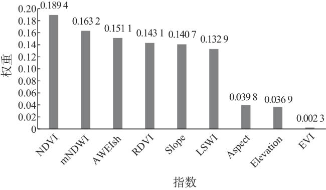
为利用基于时间序列图像的多种指数融合绘制松嫩平原西部土地类型图,利用ReliefF选择算法对融合指数中的植被和水文指数进行重要性排序,结果见图1,从结果可以看出,NDVI、mNDWI、AWEIsh、RDVI、Slope和LSWI在特征选择中具有较高的重要性,而EVI、Aspect和Elevation的权重值明显小于其他指数。因此,在后续的土地类型图绘制过程中去除EVI、Aspect和Elevation,以提高模型的效率和准确性。
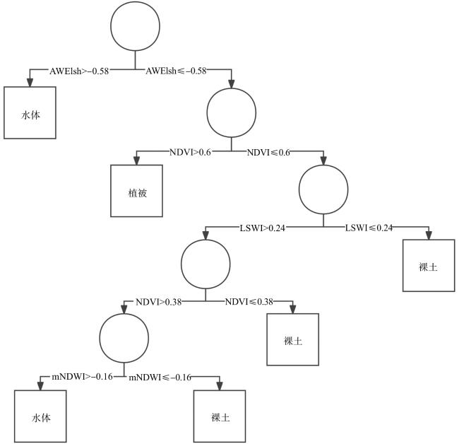
对高相关性的指数在GEE中使用CART决策树进行土地类型分类,得到各个土地类型的指数范围和剪枝优化后的决策树(图2)。可以看出,AWEIsh指数对水体最敏感,当AWEIsh值大于-0.58时,可判定为水体;在区分裸地与水体时需LSWI、NDVI、mNDWI 3种指数(LSWI>0.24,NDVI>0.38,mNDWI>-0.16)。决策树验证结果见表1,经过验证,基于CART决策树的分类结果展现出了卓越的性能,分类结果的总体分类准确率为94.26%,Kappa系数为0.912。表明分类结果的高度一致性和可靠性。这一结果不仅证实了所选遥感指数在土地类型分类中的有效性,也展现了CART算法在处理复杂遥感数据和应用中的强大潜力。
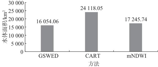
将松嫩平原西部地区CART决策树的水体结果与对应年份GSWED和mNDWI指数获取的水体面积进行比较(图3),发现两种方法对植被下水体的探测处于部分缺失状态,水体面积差值达到8 063.99和6 872.31 km²,对比发现两种方法主要覆盖了开放水体和湿地,对部分水田的探测存在缺失。
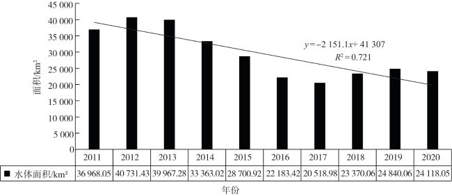
CART决策树的水体面积结果见图4,2011—2020年松嫩平原西部地区水体面积呈现出较强的年际变化。10年中水面最大值出现在2012年,达40 731.4 km²,最小值出现在2017年,为20 519.0 km²,差值20 212.4 km²,年最大增幅13.9%,最大降幅22.7%。10年来,松嫩平原西部地区年最小、最大水体面积经历了较大波动,且在不同时间段内其趋势不同。整体来看,在2017年前水体面积呈持续下降趋势,2017年后呈波动上升趋势,但整体处于下降趋势(R 2=0.721)。
2.2 土地类型转换
根据CART分类结果构建转移矩阵,2011—2020年地类转换情况见图5,水体在10年间净流出总面积4 578.88 km²,占水体总面积的18.9%。水体向其他土地类型转出最多的是植被,净转出面积5 388.78 km²,占水体总转出面积的93.3%。水体面积从36 968.06 km²减少到24 118.05 km²。
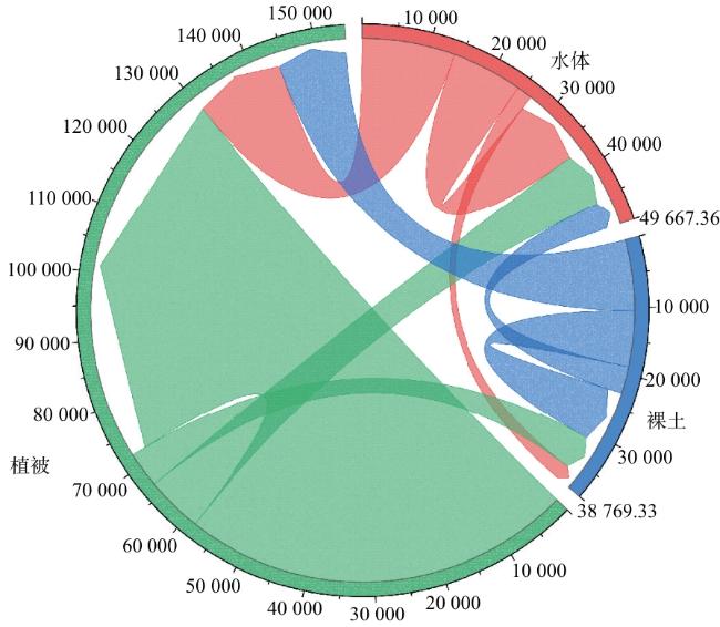
裸地与植被之间的相互转化也较强烈,2011—2020年裸土向植被转出10 509.22 km²,植被向裸土转出5 326.97 km²,植被净转入5 182.25 km²,变化主要集中于城市周边与盐碱地周边,同时在湿地景观变化中也有体现。水体与裸地之间没有大规模地类转换情况出现,裸土对水体净转出面积1 698.44 km²,占裸地总面积的10.6%。
2.3 水体面积影响因素识别
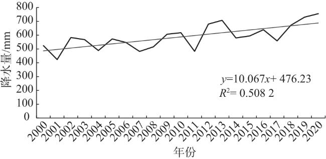
通过将水体面积变化与2001—2020年松嫩平原西部地区年平均降水量(图6)进行比较发现,20年中该地区降水量呈波动上升趋势,与水体面积变化趋势不匹配,可以得出降水不是松嫩平原西部地区水体面积变化的最直接因素。
通过分析CART结果,发现扎龙湿地及其附属大小湖泊是松嫩平原西部地区水体的主要分布区域,其属于松花江、嫩江流域。究其原因,可能是1955—1995年间,为抗击洪涝灾害和保证生产,在松花江上游修建了多处水利工程,有丰满水库、南引水库等蓄水水库,三站灌区、薄荷台灌区等灌溉水渠工程,以及防洪堤、引水渠将河水导入主干河道,以及20世纪末扎龙湿地及其水源补给地乌裕尔河和双阳河流域遭到大旱。这些自然和人为因素可能导致湿地的水量减少,湿地生态系统退化。
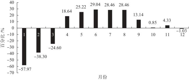
自2003年开始,随着退耕还林还草还湿工作的逐步实施,以及向重点湿地引流补水,至2013年累计向湿地补水19亿m3,使该地区主要湿地和开放水体得到部分恢复,符合2011—2013年水体增长的变化趋势。但随着城市化和工业化的推进,上游为保证其拥有充足的工业和生活用水,增大对松花江干流的截流调控,丰满水库蓄水量较往年显著增加(图7)。4—9月,水库先后启动防洪、蓄水调度模式,大量滞留上游河水,导致下游流量和干流水位较低。黑龙江省作为重要的产粮地,松花江上游主要产粮地区产量逐年增加,下游的松嫩平原西部地区获取水量开始下降。同时主要湿地扎龙地区修建的公路、村屯破坏了湿地生态系统的完整性,导致景观破碎度增大。上述因素与水体面积开始波动下降相吻合。
3 结论与讨论
本文通过阈值分析将多数据融合的时间序列植被指数和水文指数集成到CART决策树算法中,提出融合指数算法来提取水体。以往部分研究仅使用水体指数提取植被下水体,对植被指数状况的关注较少。植被指数是湿地植被下水体空间分布的关键影响因素,空间上植被与水体重合的情况下水体对植被、水体指数结果产生较大的影响。通过建立时间序列的融合指数获取松嫩平原西部10年内的水文情况,可以更深入地探索湿地水文情势的变化情况,以及裸地、水体和植被可能的发展趋势。结果表明,与GSWED和mNDWI等水体指数相比,融合指数算法提高了植被下水体的发现量,提高了湿地和水田的光谱识别。
本研究利用ReliefF算法提取高相关性要素进行CART决策树分类算法,生成时间序列的松嫩平原西部淹水地图。基于结果,得出以下结论。
(1)所提出的融合指数算法可以有效地提取淹水,研究区内融合指数算法总体分类准确率为94.26%,Kappa系数为0.912。发现水体面积比年度GSWED和mNDWI提取水体面积提高33.4%和28.4%。
(2)部分植被下水体存在空间上植被与水体重合,因此在遥感影像的地表反射与单一地类存在差异。依据NDVI、LSWI和mNDWI做出决策,能够很好地区分水体与植被、裸地和水体。
(3)获得了2011—2020年松嫩平原西部水体变化趋势,并分析出研究区内水体的主要影响因素为人为调控,为保护区的生态和水文管理提供参考。
本研究选取的数据截止至2020年,而近年来水体分布受到的干扰因素不断增加,如气候变化、人类活动加剧等,这可能导致当前的水文情势与研究期间存在一定差异。因此,未来的研究应将时间跨度延长至近期,以更准确地反映湿地生态系统在新环境下的动态变化;同时,引入更多元的气象数据、土壤湿度数据以及更高分辨率的遥感影像,从而更全面地分析水文情势的变化。结合更丰富的数据源和指数探索将深度学习算法与现有分析方法相结合,以进一步提高水体提取的精度。综上,未来的研究可在时间跨度、数据丰富度和方法改进等方面进行拓展,以更全面、深入地了解水体分布和水文情势的变化规律,为水体提取和水文管理提供科学依据。