

森林公园作为自然保护地体系的核心组成部分,不仅是生物多样性的关键庇护所,更是人与自然和谐共生的重要载体。森林公园作为环境保护、生态修复以及城市园林绿化的重点项目之一,其规划和发展受到社会大众的广泛关注。我国森林风景资源较为丰富,森林公园旅游行业发展潜力巨大。地理信息系统(GIS)作为空间数据管理与分析的核心技术,在自然资源保护与生态管理中发挥着重要的作用。近年来,随着遥感、物联网及大数据技术的融合,GIS进一步推动了国家森林公园的智慧化与精准化管理进程。张晓枫等[1]应用GIS方法对合肥滨湖国家森林公园景观质量进行评价,并基于评价结果提出了丰富植物搭配、统一建筑风格等策略。夏梦霞等[2]对张家界国家森林公园内24个代表性景观节点进行景观视觉敏感度评价,结果表明,景观视觉敏感度Ⅱ级景点较多。森林公园旅游产业规模逐渐壮大,生态、社会、经济效益也随之增长。然而,部分森林公园的规划与建设合理性有待进一步提升。首先,部分森林公园在开发过程中忽视长远发展,存在过度开发的现象,未完全落实合理开发利用生态资源的原则;其次,森林公园在建设过程中未按照前期总体规划进行,部分计划并未落实到位;最后,可能未考虑到分期分批进行项目建设,导致后续森林公园的管理、维护等面临资金短缺的问题[3]。国家森林公园规划建设应引入韧性设计原则,使公园前期总体规划更合理,可有效增强森林生态系统的适应能力,确保森林资源的可持续发展。本文应用ArcGIS软件对神灵寨国家森林公园高程、坡度、坡向等进行分析,为提升生态相似地区的森林公园韧性提供参考。
1 材料与方法
1.1 研究区基本情况
研究区位于河南洛阳洛宁县(111°72′97″ E,34°25′89″ N),隶属熊耳山北麓三官庙林场境内,是一座以典型花岗岩石瀑地貌、自然生态景观为主,河洛文化为辅的综合性地质公园[4]。研究区自然风光优美、文化氛围深厚,有丰富的地质遗迹资源,例如,北方地区独特的花岗岩峰丛地貌、罕见的石瀑和高山湿地、形态各异的象形石景观等。研究区由3个景区组成,分别为金门河景区、神灵寨景区和莲花顶景区。现已修建完成的主要有以下设施。(1)地质博物馆及科普宣传广场;(2)标识系统建设,已完成公园主题碑1座,位于地质科普宣传广场;(3)科普旅游线路建设,完成二级水泥公路建设12 km、旅游步道建设12 km;(4)其他配套设施,完成停车场建设8 000 m2。目前,研究区发展成熟,配套设施完善,基本满足游客游览需求。随着旅游业的快速发展,原有规划不能完全适应公园发展,应针对原规划中公园范围边界不明确、地质遗迹公众认知度不高等问题,进行公园用地布局优化,全面发挥其功能和作用,提高规范化程度。
1.2 数据来源
地形、道路、水文等空间图形数据是GIS分析的基础要素,根据不同数据类型可以分为矢量数据和栅格数据。本文是以空间图形数据中的矢量数据和栅格数据作为研究支撑。通过高德地图、图新地球、地理空间数据云等获取景点、水文、数字高程模型(DEM)、道路、研究范围等相关矢量、栅格数据。根据《河南洛宁神灵寨国家地质公园规划》获得神灵寨国家森林公园的规划信息,包括地质遗址景观、基础服务设施、植物信息等。
1.3 试验方法
1.3.1 高程分析
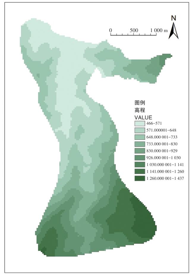
在地理空间数据云下载洛阳市30 M分辨率的DEM数据,将DEM数据导入ArcGIS软件,使用空间分析工具中的“掩膜”提取研究区的研究范围,命名为“神灵寨DEM”。根据研究区域高程的实际情况选择类别,此处分为9类,采用自然间断点法,修改色带和标注,得到高程分析图。
1.3.2 坡向分析
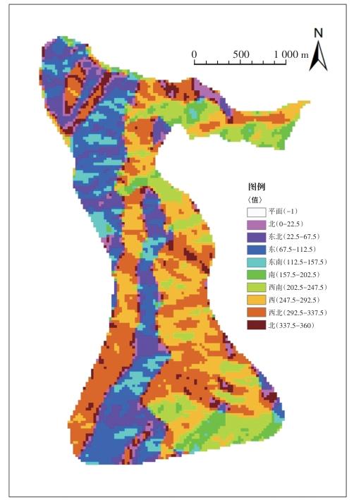
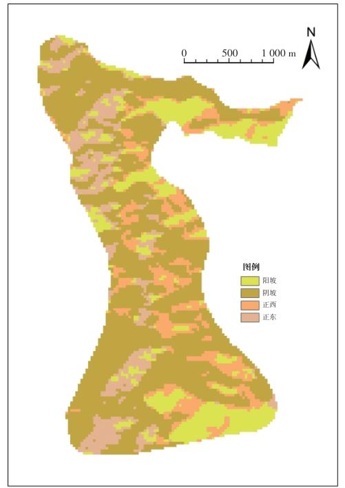
在3D Analyst工具中的“坡向”对话框中输入栅格数据“神灵寨DEM”,得到坡向分析图,按照工具系统的说明进行中文标注。因研究区属于北方,所以基础判定阳坡为南、西南、西北坡,阴坡为东北、北、东南坡。按照此原则对坡向分析图进行“重分类”,并修改标注,得到阴阳坡分析图。
1.3.3 坡度分析
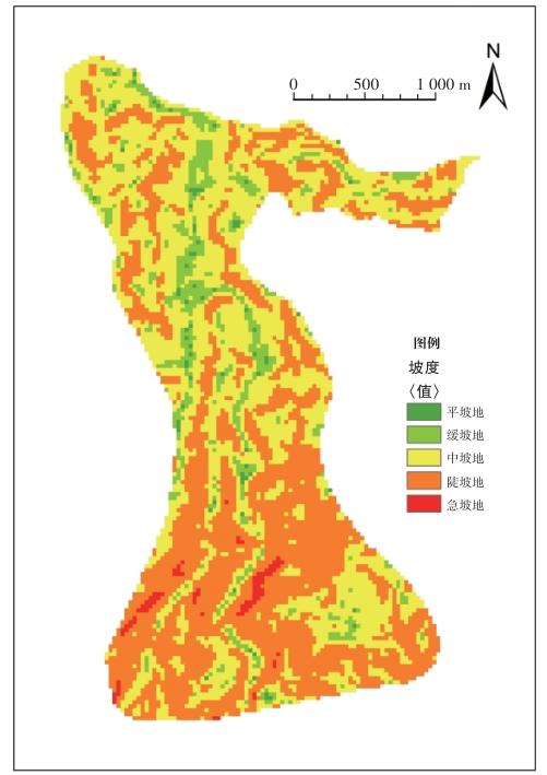
在空间分析工具中的“坡度”对话框中输入栅格数据“神灵寨DEM”,得到坡度分析数据,参考《建筑设计资料集6》将坡度分为5类。使用“重分类”工具对数据进行重新归类并标注,3°~15°为平坡地,15°~25°为缓坡地,25°~50°为陡坡地,≥50°为急坡地。
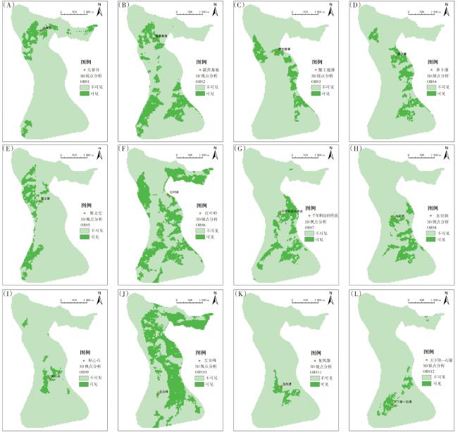
1.3.4 景点视域分析
加载数字高程模型“神灵寨DEM”和景点位置点要素“景点位置”数据,在Spatial Analyst工具中的“视域”对话框中输入栅格数据“神灵寨DEM”,输入“景点位置”,点击确定生成栅格数据,结果中像元值为“1”表示可见区域,“0”表示不可见区域。使用Spatial Analyst工具中的“重分类”,将结果分为两类:0为不可见区域,1为可见区域。点击右键栅格图层属性,选择唯一值设置颜色,添加图例和比例尺,完成景点视域分析图。
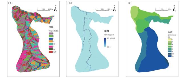
1.3.5 水文分析
DEM是比较光滑的地形表面模拟,由于DEM误差及一些真实地形的存在,使得DEM表面存在着一些凹陷的区域。在进行水流方向分析时,这些区域的存在会导致产生不合理甚至错误的水流方向。因此,在进行水流方向计算前,需对原始的DEM进行洼地填充,在ArcGIS软件中Spatial Analyst工具的“填洼”对话框中进行参数设定,得到处理后的栅格数据“填洼DEM”,根据生成的无洼地DEM来计算栅格中每个像元的水流方向。在Spatial Analyst工具的“流向”对话框中进行参数设定,输入表面栅格数据“填洼DEM”,输出结果命名为“流向DEM”。在Spatial Analyst工具中的“流量”对话框中输入流向栅格数据,选择上一步生成的“流向DEM”,输出栅格命名为“流量DEM”。在Spatial Analyst工具中的“栅格计算器”对话框中设置计算表达式Con(“流量DEM”> 1 000,1),得到栅格数据“河网”。将河流栅格数据转化为矢量数据,在Spatial Analyst工具中的“栅格河网矢量化”对话框中输入“河网”栅格数据,输入“流向DEM”栅格数据,输出数据命名为“矢量河网”。在Spatial Analyst工具中的“河网分级”对话框中输入“河网”“流向DEM”栅格数据,河网分级方法选用“Shreve分级”,得到“河网分级”数据。
1.3.6 流域分析
在Spatial Analyst工具中的“盆域分析”对话框中输入“流向DEM”,输出栅格数据命名为“流域划分”;在“河流链接”对话框中输入“流向DEM”栅格数据,输出栅格数据命名为“河流链接”;在“集水区”对话框中输入栅格数据“河流链接”,输出栅格数据命名为“小流域”。
2 结果与分析
2.1 高程
2.2 坡向
合理考虑坡向因素有利于优化资源配置,增强环境韧性。该因素直接影响光照、温度分布,阳光照射强度的差异会导致不同坡向的区域在气候条件上出现差异。例如,朝南的坡面通常接收到更多的阳光,有利于植物生长,适宜种植喜阳作物。坡向还会影响排水和蓄水能力,不同坡向的地表水流动路径不同,容易造成某些坡面积水而导致土壤侵蚀或植物根系缺氧。因此,合理利用坡向设计排水系统,可以有效防止水土流失和生态环境恶化。此外,在道路规划和交通设计中,坡向分析能够优化道路的陡峭程度,提高行车安全性和运输效率。
2.3 坡度
景区规划应充分考虑坡度变化,合理安排景点与基础设施的位置,以确保场地安全和可持续性。坡度对于水流管理和排水系统的设计至关重要,适当的坡度可以有效引导雨水流向排水设施,降低水灾风险。坡度设计可以优化利用水资源,促进自然水循环。在城市绿地和公园的规划中,需借助坡度变化创造层次感和视觉美感,提升整体空间的吸引力。此外,坡度的变化可为公共空间提供更丰富的活动场所,如步道、观景台等,增强游客的体验感。由图4可知,研究区整体坡度较大,坡度为25°,主要为陡坡地,3°~25°缓坡地主要位于景区北部,25°~50°陡坡地占比较大且集中在景区南部。在景区的规划与设计过程中,应深入考虑坡度过大存在的安全隐患以及可能给游客带来的不良体验,应进行详细的地形勘测和环境评估,以进行合适的步道和游览路线规划;优先选择稳固的材料铺设步道,并设置必要的防护设施,以保障游客的安全。在设计坡度较大的地区时应设置休息区和观景平台,方便游客在游览过程中停留、休息和欣赏风景,同时,设计适当的交通工具,如缆车或电梯,能有效提升游客的游览体验。
2.4 景点视域
2.5 水文
2.6 道路
目前研究区道路网络存在单调性,景点串联分布在主要游览线路上,在道路规划上暂存在不合理之处,如游览路线为单向路,游客步行至景区终点后需原路返回。后续规划的返程线路因考虑便利性而缺少合理的景观设计,导致游客在返程道路上无景可观,大大降低了景区的可游览性;道路功能的分区不够明确,部分道路人车共存,加大了景区内的安全风险与管理难度。
3 结论与讨论
森林公园是专业性的生态公园,不能盲目追求和效仿城市公园的一般规划模式。在保护自然景观资源不受破坏的前提下,突出森林景观为主,结合自然景观和历史人文景观进行全面规划和合理布局。根据森林公园的地域特点、发展方向等对功能区划、旅游环境容量、游览线路、景点设计、服务设施等进行规划设计,对整个公园的景观格局做出定量定性分析。在设计时,需综合考虑高程、坡度、坡向等因素,避免过度开发,确保自然环境与旅游业的和谐共生。
根据上述对研究区6个方面的韧性分析,表明该公园景点设计理念滞后、道路系统规划欠合理、地质文化特色彰显不足、日常维护管理不到位,导致景区知名度有待提升、景区基础设施有待完善。基于韧性要点分析,秉持注重场地的整体性、衔接性和合作性原则,提出以下设计策略。(1)道路方面。可在景区东北区域增加出入口,景区内游览路线呈环路,以提高游览的便利性;在景区内部尽量使用低污染的电瓶车或燃气车,并严格限制车速。周天星等[6]研究提出,山地景区交通可以选择绿色低碳环保的交通方式,实现景区发展的可持续性。(2)文化方面。在景点设计中融入场地的地质文化,增强游客的认同感和归属感;保护和展示当地的传统文化,将地质博物馆展馆的建筑设计与生态保护结合,吸引更多游客和学生前往参观学习。(3)专业调研方面。在设计前进行生态研究和评估,以确保方案的科学性;对公园内空气、水质、土壤等进行取样检测,并根据测试结果进行调整,建立反馈机制,以便及时调整管理措施和设计方案。构建生态环境监测指标体系有利于公园的总体建设与管理,促进公园生态环境韧性发展[7]。(4)景观设计方面。在景区地势较平缓的北区设计生态湿地景观等景点,根据不同需求进行调整和再利用;鼓励当地社区参与设计和管理,推广韧性设计的理念,同时提高公众的社会责任感。王子尧等[8]研究发现,南宁园博园采石场花园集合了看台、栈桥、高架步行桥等游览方式,形成了独特的立体游览体系。(5)管理维护方面。研究区游览路线主要沿河道展开,应重视河道后期管护,定期对河道进行全面清理、疏通,以确保河道内无污染漂浮物;不盲目开挖疏通沟渠,以免改变公园地质环境与水文条件。张磊[9]研究表明,定期开展河道清淤、检查水文站以及防洪防御系统等工作,有利于保障河道健康,促进景区长远发展。上述韧性设计的引入有利于保护森林资源,提高了研究区的景观韧性。